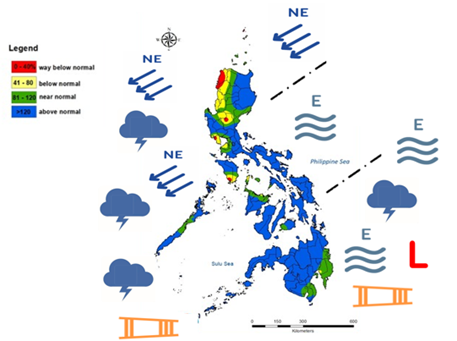
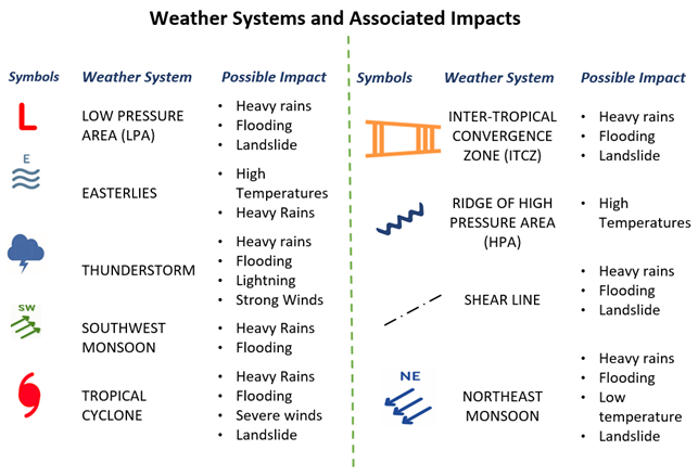
In March, the country experienced various weather systems, including the Northeast (NE) monsoon, shear line, intertropical convergence zone (ITCZ), easterlies, low pressure area (LPA), and localized thunderstorms.
On 25 March 2025, PAGASA issued a Press Release for the termination of the Northeast Monsoon, signifying the start of warm and dry season.
As illustrated in Figure 1, above normal rainfall was observed in most parts of Luzon except in western section which received below or near normal rainfall. Most parts of Visayas received below normal rainfall while Mindanao had a range of below normal to above normal rainfall.
The highest recorded rainfall for the month was at Borongan Synoptic Station (294.0 mm), followed by Catbalogan Synoptic Station (177.5 mm), and Guiuan Synoptic Station (175.4 mm).
No tropical cyclone entered or developed within the Philippine Area of Responsibility (PAR) during the month.
SOIL MOISTURE CONDITION
TEMPERATURE
On 25 March 2025, PAGASA issued a Press Release for the termination of the Northeast Monsoon, signifying the start of warm and dry season.
As illustrated in Figure 1, above normal rainfall was observed in most parts of Luzon except in western section which received below or near normal rainfall. Most parts of Visayas received below normal rainfall while Mindanao had a range of below normal to above normal rainfall.
The highest recorded rainfall for the month was at Borongan Synoptic Station (294.0 mm), followed by Catbalogan Synoptic Station (177.5 mm), and Guiuan Synoptic Station (175.4 mm).
No tropical cyclone entered or developed within the Philippine Area of Responsibility (PAR) during the month.
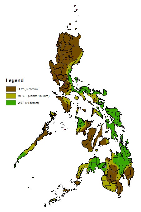
SOIL MOISTURE CONDITION
- Wet – Aurora, most parts of Bulacan, Alabat Infanta, Tayabas, Aborlan, Camarines Norte, Albay, Sorsogon, Catanduanes, Mambusao, Eastern Visayas, Bukidnon, Davao del Norte, and Lanao del Sur
- Moist – Mulanay, Oriental Mindoro, Northern and Central parts of Palawan, Camarines Sur, Masbate, Siquijor, Zamboanga del Norte, and Maguindanao
- Dry – Rest of the country
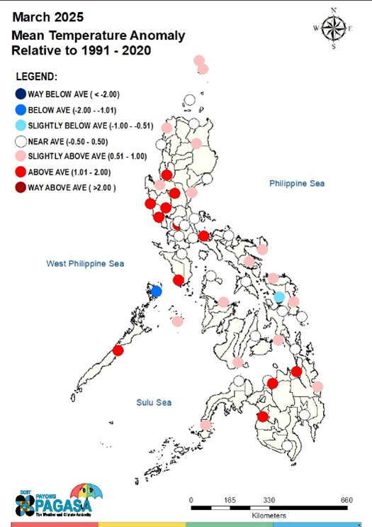
TEMPERATURE
- Generally, most parts of the country experienced near-average to warmer than average mean surface air temperatures.
- Subic, Zambales recorded the highest maximum temperature of 37.4°C on March 28, while Baguio Synoptic Station registered the lowest temperature at 13.2°C on March 22.

FARM OPERATIONS
The agricultural technicians, farmers, and farm enthusiasts may continue to browse some tips and additional knowledge on potential crop production, early warning for pest and disease infestations and water management strategies for specific areas by visiting the website of Department of Agriculture in their respective regions. For daily farm weather and climate conditions, you may visit PAGASA website (https://bagong.pagasa.dost.gov.ph/)
| • Land and Seedbed Preparations • Planting and Transplanting • Weed Management • Field monitoring • Pest and diseases management |
• Water management • Fertilizer Application • Post-harvest/Harvesting • Cleaning and management • Harvesting |
The agricultural technicians, farmers, and farm enthusiasts may continue to browse some tips and additional knowledge on potential crop production, early warning for pest and disease infestations and water management strategies for specific areas by visiting the website of Department of Agriculture in their respective regions. For daily farm weather and climate conditions, you may visit PAGASA website (https://bagong.pagasa.dost.gov.ph/)
| CROP STAGES | REGION/CROPS |
| Land and Seedbed Preparation (including preparation for garden plot, urban gardening, and upland farms), (irrigated and rainfed farms) | Ilocos Region, Cagayan Valley, Cordillera Administrative Region, CALABARZON, MIMAROPA, Bicol Region, Western Visayas, Central Visayas, Eastern Visayas, and Northern Mindanao |
| Planting and Transplanting (broadcasting / direct seeding – for rice, corn, conventional way/ by rows - other cash crops) |
|
| Vegetative Stage (tillering, head development) |
|
| Reproductive Stage (Heading – rice; Tasseling/Silking – corn) |
|
| Maturing/Ripening |
|
| Harvesting Stage |
|
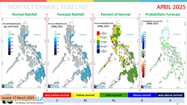
- The weather systems that will affect the country in April are the ridge of high-pressure areas (HPAs), easterlies, intertropical convergence zone (ITCZ), low-pressure areas (LPAs), and localized thunderstorms.
- Zero or one (0–1) tropical cyclone (TC) may enter or develop within the Philippine Area of Responsibility (PAR) during the month.
- As illustrated in Figure 2, near to below normal rainfall will be experienced in Luzon and Visayas with some patches of way below normal in Luzon. Mindanao will generally have near normal rainfall conditions.
FARM ADVISORY
Extreme heat causes internal water stress in crops, weakens, and destroys standing crops. Watering crops during early morning and evening periods will help alleviate stress on crops. In areas with insufficient water supply, drip irrigation is one economical way of maintaining the moisture required by the crops. Mulching can also be done to prevent the rapid loss of soil moisture so as to maintain the good growing condition of the crops.
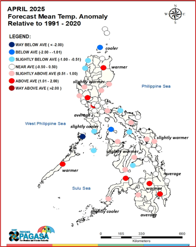
Forecast Mean Temperature Anomaly
Near to above average surface temperatures are expected in most parts of the country, with several areas showing patches of slightly cooler conditions, particularly in Northern and Southern Luzon.
ENSO ALERT SYSTEM STATUS
Recent DOST-PAGASA’s climate monitoring and analyses show that La Niña conditions are no longer present in the central and equatorial Pacific (CEEP). The sea surface temperature anomalies (SSTAs) reached ENSO-neutral levels. La Niña-like patterns of above normal rainfall in some parts of Luzon, most parts of Bicol, eastern Visayas and northeastern Mindanao are not likely to linger, as noted in the forecasts.
With this development, DOST-PAGASA ENSO Alert and Warning System Status is “INACTIVE” (El Niño or La Niña conditions are not observed or expected to develop in the tropical Pacific within the next three (3) months) and ENSO-neutral condition is favored until September - October-November 2025 season.
PAGASA will continue to closely monitor the climate conditions that may affect the country and updates shall be issued as appropriate. For further information, please contact the Climatology and Agrometeorology Division (CAD) at telephone number 8284-0800, local 4915.

For the simplified version, please download at: https://bit.ly/SimplifiedMPARO
With this development, DOST-PAGASA ENSO Alert and Warning System Status is “INACTIVE” (El Niño or La Niña conditions are not observed or expected to develop in the tropical Pacific within the next three (3) months) and ENSO-neutral condition is favored until September - October-November 2025 season.
PAGASA will continue to closely monitor the climate conditions that may affect the country and updates shall be issued as appropriate. For further information, please contact the Climatology and Agrometeorology Division (CAD) at telephone number 8284-0800, local 4915.
For the simplified version, please download at: https://bit.ly/SimplifiedMPARO

Prepared : RAAM
Checked : MEVT
Approved : TAC
Uploaded : RVDD
Checked : MEVT
Approved : TAC
Uploaded : RVDD